
First Published in P.O.B. Magazine October 2018
No doubt many of you have already heard about the recent article that appeared on Bloomberg.com entitled “Land Surveyors Are Paying the Price of Progress†(“Paying the Priceâ€).[1] In case you missed it, “Vizaline†is a company founded in 2014 that, “uses public information to draw lines on a map showing property boundaries. They do this mostly for small banks who need to visualize the properties they are holding.â€[2] That article goes on to say: “Since its founding, the company has grown to six employees in Mississippi. It operates in five southeastern states and provides its services to over 30 banks, mostly in Mississippi.â€[3]
The Mississippi Board of Licensure for Professional Engineers and Surveyors filed a complaint against Vizaline for practicing surveying without a license, in violation of Mississippi law. Vizaline filed a counter-complaint, supported by an organization called the “Institute of Justice,†for violation of Vizaline’s First Amendment free speech rights. I do not have the details of these complaints as of this writing and the case will be litigated to some final resolution, but in the meantime this case highlights some problems for both Vizaline and the surveying profession.
What is a survey of property?
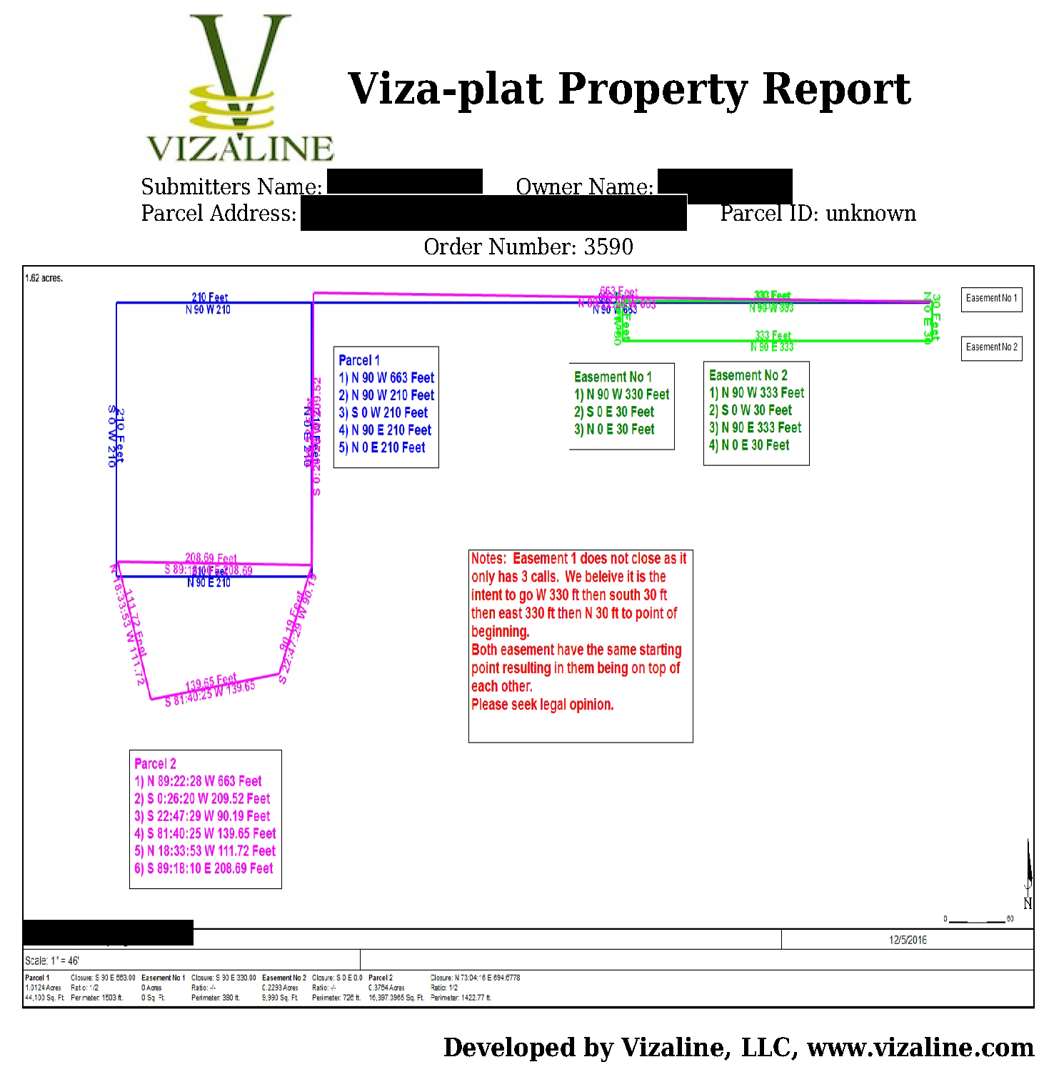
Conveniently, “Paying the Price†had a link to a typical Vizaline, “Viza-plat Property Report.†See the Viza-plat and Report, below. As reported, Vizaline is claiming that its “Report†isn’t a survey. It includes a disclaimer that, “It is not a Legal Survey, nor is it intended to be or replace a Legal Survey.†I’m not exactly sure what a “Legal Survey†is, unless this implies that the only ‘legal’ 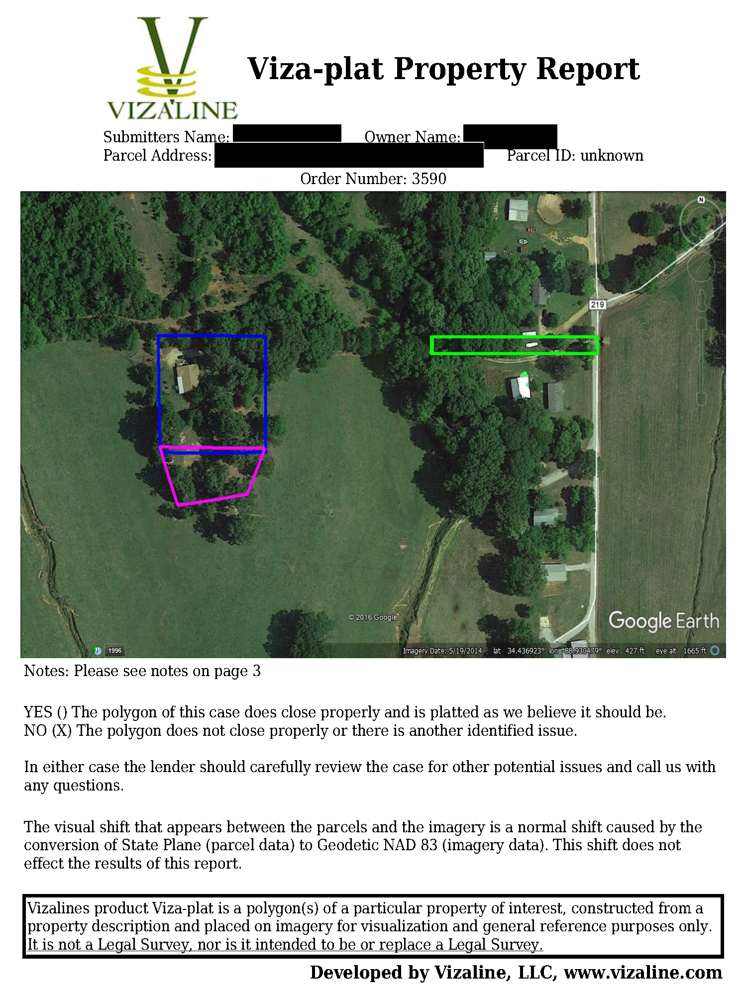 survey is a survey performed by a duly-licensed land surveyor and a tacit admission that Vizaline’s ‘survey’ is otherwise illegal. Although our licensing laws (all 50 states) are somewhat similar, there are differences in all of them, and whether Vizaline is in violation of any one of them will require a case-by-case examination.
I perform property boundary surveys, which, in the final analysis, are well-reasoned opinions on the location of property lines on the ground. I utilize the client’s deed and the deeds of adjoiners, the extrinsic and collateral evidence of the true location of the property boundaries (occupation, fences, oral evidence, even aerial photos, etc.), and render a ‘report’ of the property line locations in the form of a map or plat of survey that graphically depicts the property lines, and contains a description and pertinent surveyor’s notes. I see similarities between what I do and what Vizaline has done with its report.
 Considering Vizaline’s report, the immediate issue that comes to my mind is: What is Vizaline doing that could not be accomplished by downloading the tax assessor’s map of the property? Unless it is this one thing: Vizaline knows what surveyors know about tax assessor’s maps, they are notoriously unreliable for property location purposes (some better than others) and are only intended to represent a parcel of land for taxing purposes. No one in their right mind would rely on it for anything else, especially property line location. I know that my own house in Jefferson County, Alabama, is physically depicted on my next-door neighbor’s lot when the aerial mapping layer of the county’s GIS is turned on, and the road in front of my house is going through the houses on the other side of the street. Further down the block they have lots overlapping, but they are tax maps.
The example Vizaline report is not utilizing tax map locations. It’s obvious that Vizaline is consciously deciding where property lines are located on the ground and depicting those locations on their map, disclaimers notwithstanding. And, of course, charging their client’s for performing these services. This is a distinguishing characteristic of professional services—charging for those services. I often use the legal profession to make this point. Anybody can be an attorney; an attorney is simply one who represents another. You can be your own attorney or with a power of attorney you can represent someone else. It’s when you are paid by someone else to represent them that you step into the role of lawyer requiring, by law, to be duly licensed. Go practice the law without a license and see what happens to your free speech rights.
Speaking of free speech, I know that not all speech is free. One cannot freely disparage or slander another without the possibility of legal reprisal, this includes the slander of someone’s good title. One aspect of title to property is the occupation of that property. Vizaline’s depiction of the property in its report could be slandering the title of an adjoiner or even the subject property owner. Without going into a full-blown discussion on slander of title, the slanderous accusation is complete when it is published, and it is published when communicated to someone other than the title holder—say when Vizaline turns the report over to its Banker client. These are just a couple of problems with the unqualified rendering opinions on the location of property lines. There are many more examples that space will not allow.
The protection of property rights
The only reason to license surveyors and regulate the practice is to protect the property interests of the landowning public. On this issue licensing boards agree with nearly identical language. “The Mississippi State Board of Licensure for Professional Engineers and Surveyors was created to ensure the safeguarding of life, health and property and to promote the public welfare.â€[4] And the Mississippi Board, like other similar boards is authorized to achieve that goal.[5] Tangentially, surveyors play a role in safeguarding life and health, but it is the safeguarding of property and the associated rights (property rights; including the location of that property on the ground) that is the core issue. There is no other reason to regulate the profession.
In my estimation, this is where Vizaline steps over the regulatory boundary. At best, disclaimers aside, Vizaline is providing its clients (admittedly Bankers and not the landowners) with a visualization of the location of property lines on the ground. Bankers are not the only ones with property interests at stake. Surveyors also work for bankers and others who may not be the actual landowners, but the surveyor’s goal is to identify the true and correct location of the property lines on the ground, regardless of who is paying them.
Surveyors are in the business of protecting the location of the property rights, this does not appear to be the goal of Vizaline. At worst Vizaline may be perpetuating fraudulent misrepresentation[6] of those lines or even slander of title. If anything, experience has taught us that when an unsophisticated landowner gets their hands on such a map they will rely on it to their detriment. In many cases they think a tax map of their property is as good as a survey and those maps have disclaimers as well. When detrimental reliance takes place, the fraud is complete.
Regulatory overreach
This is where the surveying profession has a problem. “Paying the Price†referenced the Pennsylvania case of Southeastern Reprographic v. Bureau of Professional and Occupational Affairs, et al (the “Boardâ€),[7] on the issue of regulatory overreach. Utilizing statutory language similar to Mississippi’s (and similar to many other jurisdictions), the Board concluded that an unlicensed firm performed “engineering surveys†in violation of the law when it collected spatial data on power company facilities “in an area that spanned six or seven counties, included over 100 square miles of land, and involved 3,200 miles of electrical lines and 100,000 point locations requiring inventory,†utilizing “mapping grade GPS/GIS technology,†locating “assets to sub-meter accuracy. … Based on this evidence, the Board found that [the company’s] field staff, unlicensed under the Law, used GPS/GIS equipment, mathematical calculations and other tools to search, identify and locate the x-y coordinates of [the power company’s] assets on the Earth’s surface.â€[8] The Board determined that Southeastern was practicing surveying without a license; the court overturned the Board’s decision.
Mississippi’s definition of surveying is almost the same as Pennsylvania’s:
“The practice of ‘surveying,’ … shall mean providing professional services such as … mapping, assembling and interpreting reliable scientific measurement and information relative to the location, size, shape or physical features of the earth, improvements on
the earth, the space above the earth, or any part of the earth, utilization and
development of these facts and interpretation into an orderly [map], plan
or report….â€
In this day-and-age, this language is too broad. According to this definition, Google, Esri, Garmin, Microsoft and others are surveying every day, without a license, and they are crossing jurisdictional boundaries doing it. Today, anybody with the right tools can be an expert measurer. If expert measuring ability is all the land surveying profession has, we have nothing. You can’t regulate the tools and you can’t regulate expert measurement ability, go ask the Pennsylvania Board.
This is what Vizaline is arguing, but they miss the point. The point is the property interest of the landowning public, not whether they can use a computer and a Google Earth image. The real question for Vizaline is, can they give an opinion on the location of property lines on a georeferenced map, which is the tech-savvy equivalent of the on-the-ground location? The real question for the land surveying profession is, are we in the property rights business or merely expert measurers? If we allow the one job we have (the location question) to get away, then we will be, as the article suggests: Paying the Price of Progress.
Endnotes:
[1] “Land Surveyors Are Paying the Price of Progress,†by Stephen L. Carter, Bloomberg.com, July 19, 2018. Two related articles appeared on the online version of the Mississippi Clarion Ledger. “Madison tech-biz says rights are being violated by state board trying to shut him down†(“Madison tech-bizâ€), by Jimmie E. Gates, July 13, 2018, and “Government overreach is killing this Mississippi tech startup†(“Government overreachâ€), by guest columnists Brent Melton and Scott Dow, July 24, 2018. Melton and Dow are apparently the co-founders of “Vizaline,†a tech startup that uses deed descriptions to draw property lines on Google satellite photos, to be used by banks and other lending institutions to “visualize†the property these institutions are lending money on.
[2] “Madison tech-biz.â€
[3] Id.
[4] Rule 30-901-1.1, Mississippi Administrative Code.
[5] See, Rule 30-901-1.2, Miss. Admin. Code
[6] “Fraudulent misrepresentation. A false statement as to material fact, made with the intent that another rely thereon, which is believed by the other party and on which he relies and by which he is induced to act and does act to his injury.†Black’s Law Dictionary.
[7] Southeastern Reprographic v. Bureau of Professional and Occupational Affairs, the State Registration Board for Professional Engineers, Land Surveyors and Geologist, 139 A.3d 323 (Pa.Cmwlth, 2016). The court concluded: “Applying the above analysis, we [the court] conclude that the Board erred in concluding that [Southeastern] engaged in the practice of land surveying ….†Id. at 333.
[8] Id., at 326.